

Why is Glen Iris the shape it is?
- scraze

- Aug 22, 2025
- 7 min read
A reader of my Ashburton book suggested that I write a book about another underrepresented suburb. I’ve got a bit of time on my hands at the moment so I thought, “Why not? I suppose I kind of know how to do it now. How hard can it be?”
There’s already a book (kind of) about Ashwood so why don’t I see if there’s a book in neighbouring Glen Iris?
Surely in 170 years of whitefella settlement something interesting happened there?

Early signs were not encouraging. My literature review of Glen Iris was done in about five minutes and that’s not because I’m super-efficient. It’s because there’s not much literature to review.
Glen Iris makes a token appearance in the two histories of the City of Malvern[1] and there’s a few histories of Glen Iris-based schools and churches but that’s about it. The only book dedicated to Glen Iris itself is Early Glen Iris, published in 1992.[2] I say book but it’s more like a pamphlet. It’s by Gwen McWilliam so it’s thoroughly researched but it only makes it up to the start of the 20th century.
So good news - there’s a gap in the market for local histories on subur!
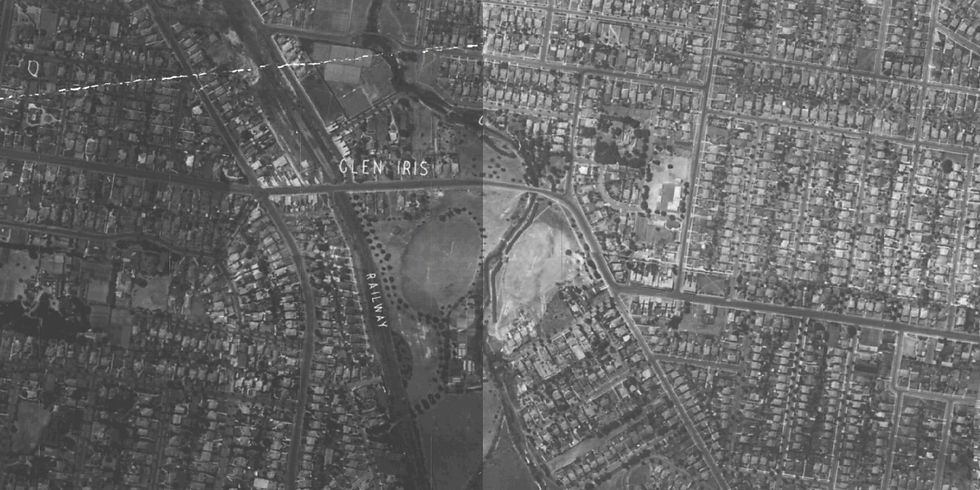
The next rule in “how to start writing a suburban history book” is “looking at maps”. As you can see on the map below, Glen Iris is a very neat, rectangular-shaped suburb.

One of the things I knew about Glen Iris is that it is really old. Looking at the map, it occurred to me how strange it was that it was split by a railway line, a creek AND a freeway. There's no way that was its original configuration when Hoddle wandered down to KooyongKoot to survey the land. From this map, you can see it has distinctly separate geographic sections:
The Monash Freeway, the sports ovals and KooyongKoot running down the left-of-centre
East Glen Iris up the hill towards Ashburton and incorporating the section between High Street and Dent Street
North-East Glen Iris in the rectangle between Summerhill Road and Baker Parade
West Glen Iris from the train station towards Malvern, including Harold Holt Swim Centre
A little pocket in the north-west between the Monash Freeway and Toorak Road where Tooronga Shopping Centre sits.
So how did Glen Iris come to look like this? And what does this mean for its suburban identity?
Hmm. Maybe there is something here.
Glen Iris’ geographic boundaries
To get me started, I asked AI about the divisions of Glen Iris. It’s always good for a laugh when it comes to local history. It did not disappoint. It said that Glen Iris was divided north and south by the South-eastern Freeway in the 1960s.
Note to self: don’t bother asking AI anything again.
That said, it is not unusual for a Melbourne suburb to sit on two sides of a major road. Ascot Vale, Moonee Ponds, and Essendon all span Alexandra Parade, as one example. A division by a railway line is less common. Mostly the train lines were built before widespread settlement and the suburbs zoned around them. There’s a few exceptions. West Footscray spans the Sunbury Line; Coburg North the Craigieburn Line. But the Glen Iris line was not one of them.
Division by waterway? That is unusual. To the British settlers, waterways, creeks and rivers acted as natural boundaries before they got around to building roads. Hoddle showed this in the late 1830s when he came along to map Prahran, Malvern and Boroondara. As you can see on the map below, he set the Parish of Boroondara to the east of KooyongKoot/Gardiners Creek, and the district of Gardiner to the west of it.
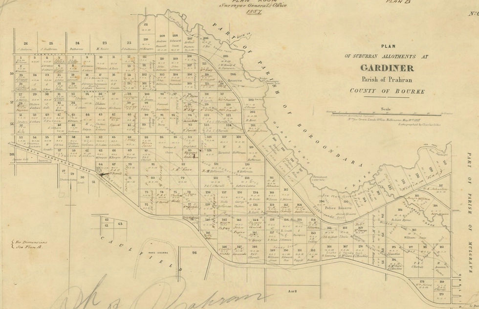
In keeping with waterways as a natural boundary, “Glen Iris” - as this map below from Early Glen Iris shows - was originally situated entirely on the eastern side up Muswell Hill.

As we can see, the first zoning of “Glen Iris” did not cross KooyongKoot.
First administrated under the Shire of Boroondara, then the City of Camberwell, this area was where the Glen Iris Methodist Church and the Glen Iris School, opened in 1872, were situated. Over time, certain newspaper editors and property developers gave the moniker "Glen Iris Valley" to the uninhabited area known as Kooyong Koot.
The creation of the present-day boundaries of Glen Iris
With so little literature to go on, this is the theory I have pieced together on why Glen Iris looks the way it does today on the map.
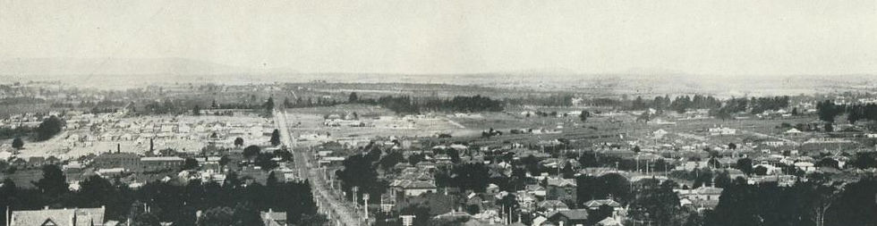
As far as I can uncover, various officials created the boundaries of present-day Glen Iris out of a series of arbitrary decisions made between 1890 and 1930. They seem rather baffling now (and there is one piece of evidence they were at the time too) but we must remember that up until the 1910s, most of the land that is now modern-day Glen Iris was either swampy waterway, or market gardens and farmland. You can see from this photograph in 1912, taken from the top of the Malvern Town Hall, development was still very much up the Malvern-end of High Street.
Official decisions on creating geographic boundaries were made to deliver services, like mail and telephone connections, as efficiently as possible. These boundaries tended to reflect the scarce population of the area at the time and the roads available to get to people.
Decision 1: We’ll build a train line to Glen Iris
In 1878, the former Shire of Gardiner was officially absorbed into the Shire of Malvern. Not too many people noticed since development was still centred further up High Street around Glenferrie Road.
A few years later, as Melbourne’s railway fever dream of the 1880s began to take hold, public speculation on a railway line out to the Glen Iris Valley began. This caused speculators to snap up land along the proposed line. The placement of the Glen Iris train station at High Street in 1890 reflected the original intention of the line to join up with the Outer Circle Line around Oakleigh further south. Naming it “Glen Iris” refers more to the immediate area being referred to as “Glen Iris Valley” than the semi-rural residential area on the hillside on the other side of Kooyong Koot.
When the fever dream broke, the Glen Iris line’s extension never eventuated. With all the discussion about the Suburban Rail Loop these days, we can only imagine what could’ve been for public transport in Melbourne’s south-eastern suburbs if it had been built.
The other new railway stations along the Glen Iris line were given names that reflected the recent legacy of the Valley’s nearby villages: Darling, Gardiner and Tooronga. Property developers began attaching the “Glen Iris” assignation to land sales, as you can see in this flyer:
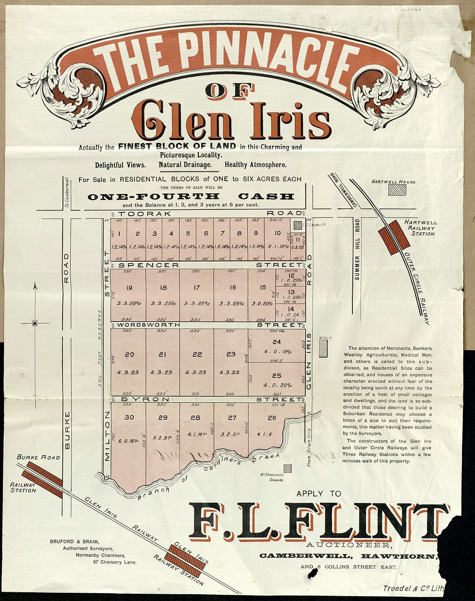
This created the first association of “Glen Iris” to a residential area outside of the original hillside one. The hillside Glen Iris residents, now under the jurisdiction of the neglectful City of Camberwell, then had to look on in dismay as the City of Malvern invested financially in developing the new side of Glen Iris.
Decision 2: Let’s extend the High Street Tram from Prahran down to Glen Iris station
From 1911, the privately-owned tram companies began rolling out electric trams across Melbourne’s network. Determined to be part of it, Malvern Council provided funds for the Prahran and Malvern Tramways Trust to work on extending the High Street tram down from Prahran to Glen Iris Railway Station. By 1915, the tram made it to Glen Iris Station. The residents of East Glen Iris looked on with more dismay and began an ill-fated push to extend the tram line up their way.
Decision 3: We need to zone the area for mail delivery
Thanks to some excellent sleuthing assistance from Alex at the State Library, it appears it was the Postmaster-General who officially re-named the sections of old Gardiner and Tooronga to Glen Iris around the mid-1920s. This shift began a few years earlier, when the Postmaster-General decided to build the “Glen Iris” Post Office on the intersection of High Street and Malvern Road.
Unfortunately, he was not a man who published a lengthy explanation for why he decided to do this for a 21st century historian to have her “THAT explains it!” moment.
My theory is that he needed to create a reliable mail delivery route on established roads that could cross over Kooyong Koot. At the time, there were only two bridges that crossed this waterway; one at Toorak Road at Tooronga, the other at High Street at Glen Iris Station. If the mail is coming from Melbourne down Toorak Road, it could be delivered in a circuit along Toorak Road to Warrigal Road (Boundary Road as it was then); down to the developing north side of Ashburton; then along High Street to cross the bridge and level crossing at High Street; left down Malvern Road to Wattletree Road; then a right turn at Tooronga Road to get back up to Toorak Road.
It was a neat, rectangular and convenient route. But the change in boundaries extended the suburb of Glen Iris into two local government jurisdictions, where it stays today. These would eventually become the City of Stonnington and the City of Boroondara.
Reactions to the change
If there was a widespread uproar about the boundary changes by residents, it was not the subject of letters to the newspapers. However, in 1939 a person signing themselves, “Where are We?” gave a clue to community attitudes about the change:

“Sir – The reported comment by the Postmaster-General (Mr Cameron) on the need for co-ordination in naming suburbs and other centres is interesting. The district in which I live was arbitrarily re-named Glen Iris by the Postal Department when the postal district numbers were introduced. This area, between High Street and Gardiner’s Creek, from Tooronga to Burke Road, is known to local residents as Gardiner or East Malvern. The name Glen Iris, used in telephone and other directories, is misleading to strangers.
A branch post-office in Burke Road “Glen Iris" has painted on the front window the words, “Gardiner Post-office”. Incidentally, the Malvern Post-office and telephone exchange buildings are in Armadale – if we are to believe the postal officials. Actually we do not.”
It seems that officials can call an area whatever they wanted but it did not mean the people that lived there were going to identify with it.
In the decades to come, we now know that people will want to identify with Glen Iris so much that they would lobby to change their street designation to Glen Iris… but that’s a story for another day.
References
[1] Cooper, John Butler, The History of Malvern (Melbourne: Specialty Press, 1935). Strahan, Lynne, Private and Public Memory: A History of the City of Malvern (Hargreen Publishing Company, 1989).
[2] McWilliam, Gwen, Early Glen Iris (Camberwell: Camberwell Public Libraries, 1992).
[3] Glen Iris Railway.


Comments